From hidden highways to global action: a planetary blueprint to advance conservation of marine megafauna

Ana M. M. Sequeira
Australian National University
DOI: 10.25453/fpprize.32065842
Global tracking of marine megafauna space use reveals how to achieve conservation targets (Science, 2025)
“A third of marine megafauna are currently threatened with extinction, and they are essential for a healthy ocean, one of Earth’s most important life support systems.”
Planet Earth is at a pivotal moment. Charismatic, highly migratory marine megafauna, including whales, sharks, turtles, polar bears, and penguins, are edging toward global extinction under intensifying human pressures: industrial fishing, ship traffic (with collision and noise risks), plastic pollution, and climate-driven ocean change. At the same time, the Kunming–Montreal Global Biodiversity Framework (GBF) and the UN High Seas Treaty have created unprecedented momentum to protect and effectively manage at least 30% of the ocean. This raises a critical question: where should those 30% be placed? This is the central challenge addressed in our research paper.
We tackled the gap between broad conservation ambitions and the ecological reality of species that traverse entire ocean basins. Because marine megafauna migrate across jurisdictions and into the high seas, they are particularly difficult to protect. Yet they also play pivotal functional roles in marine ecosystems: they assist with moving nutrients, influencing food webs, and supporting carbon and energy flows that help stabilize the ocean and its climate-regulating capacity. Protecting these species, especially in the areas they rely on for feeding, mating, and migrating, is therefore essential.
Our research reveals that marine megafauna concentrate their movements in identifiable migratory corridors and residency areas shared across species. Yet these critical areas remain largely unprotected: less than 5% currently overlap with existing marine protected areas (MPAs). We found that even with a 30% expansion of protected areas, marine megafauna would remain substantially unprotected because their key habitats overlap almost universally with plastic pollution, intense shipping, and ocean warming, and significantly with fishing pressure. This underscores the need to pair spatial protection with targeted mitigation to reduce the human pressures threatening these species. Closing the gap between expanded protection and meaningful threat reduction is essential not only to slow biodiversity loss but also to safeguard the ocean’s capacity to regulate climate, sustain fisheries, and support human well-being.
Against this backdrop, the paper presents a set of actionable solutions for improving ocean protection. First, it positions Important Marine Megafauna Areas (IMMegAs, Figure 1) - the migratory corridors and residency zones identified through decades of tracking - at the core of future MPA expansion and network design. This provides a clear, policy-ready answer to where the 30% protection should be implemented, both within national waters and in areas beyond national jurisdiction under the High Seas Treaty. Second, it calls for targeted mitigation focused on threats that directly cause mortality, particularly in shipping and fishing. Existing measures include wildlife-traffic separation schemes, ship slow-down zones to reduce collision and noise risk, and validated bycatch reduction methods, for which strengthened monitoring and compliance will be essential. Finally, the paper highlights that formalized global cooperation will be crucial for protecting highly mobile species whose habitats cross borders.
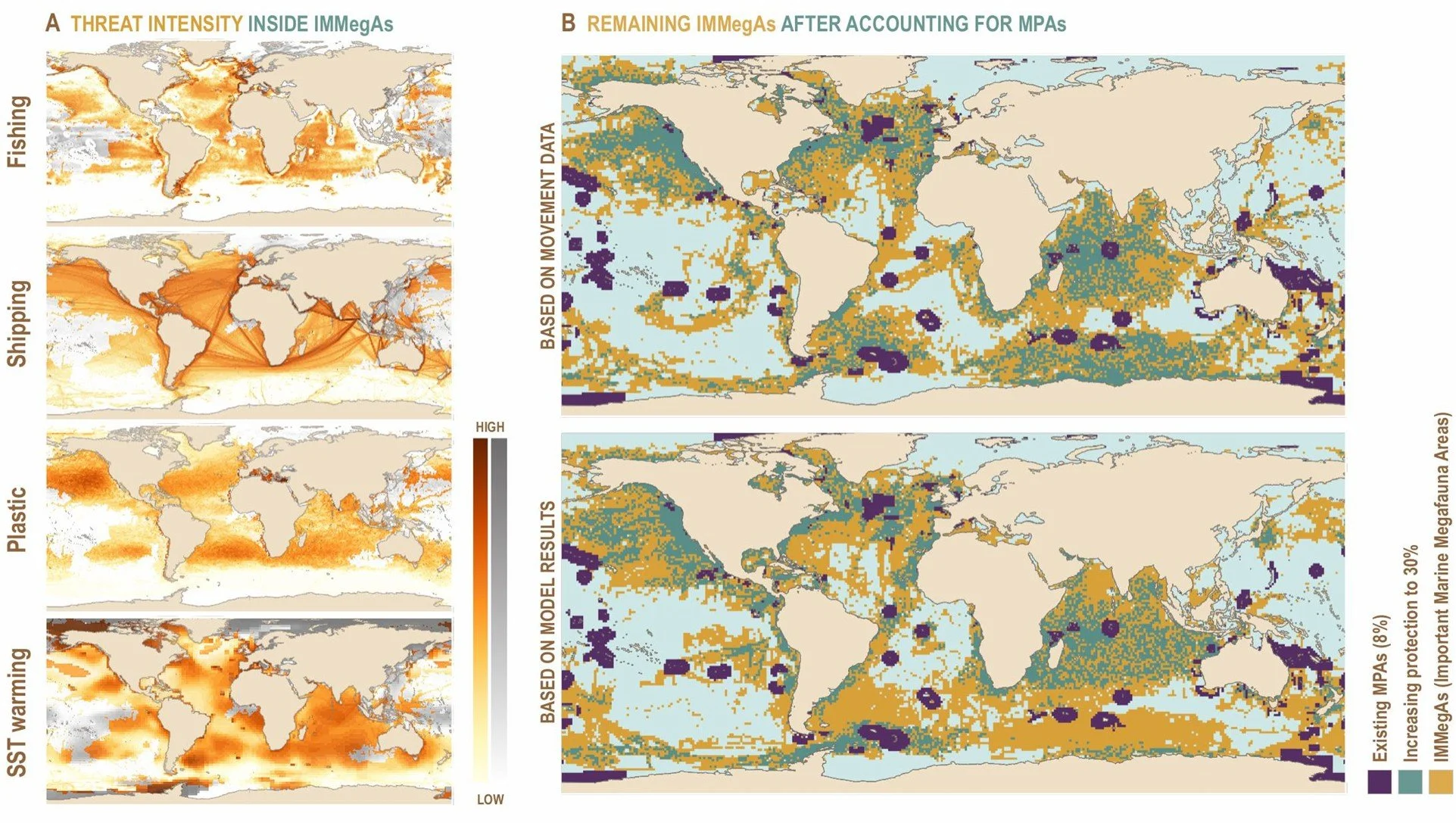
Figure 1: Increase in area protection to 30% will leave ~60% of IMMegAs exposed to major anthropogenic threats. (A) Maps depicting average threat intensities for major anthropogenic threats with a global footprint: (from top to bottom) fishing, shipping, plastic pollution, and sea surface temperature (SST) warming. Displayed with an orange color palette are the threat intensities occurring inside IMMegAs, while a gray color palette is used to show the threat intensities outside IMMegAs. Note that we considered noise to be ubiquitous, as no noise dataset is currently available at the resolution needed for a global analyses. (B) Maps showing how much the increase in MPAs from the current 8% (purple) to 30% (green) would cover from our prioritization of IMMegAs detected from movement data (top map) and from our modeling predictions (bottom results). Note that coverage by MPAs only translates into protection from the anthropogenic threats considered if they are designated with the highest level of protection (i.e., with no activities allowed), and even then, MPAs could only be effective for protection from fishing and shipping, leaving plastic and warming threats to continue to affect species. In addition to the increase in the current extent of MPAs, the introduction of mitigation strategies will assist in reducing the impact of existing threats and therefore the likelihood of human-induced extinctions.
The research has already delivered real-world impact by reshaping how conservation policy, industry, and science communities understand and protect marine megafauna. We compiled the largest global tracking dataset for marine megafauna covering over 70% of the global ocean. This was possible by mobilising hundreds of contributors around the world to build a long-term international collaboration for global megafauna conservation. Our work provides policy-ready, evidence-based guidance to inform the implementation of the GBF and the High Seas Treaty by pinpointing where protection will be most effective for highly mobile species. Importantly, it lays the groundwork for a global IMMegA registry to connect governance needs with data-driven conservation decisions and to expand real-time monitoring platforms to enable coordinated international enforcement and adaptive management as species shift under climate change. Together, these accomplishments demonstrate that the research advances science while actively shaping policy, industry practice, and global cooperation toward a more resilient ocean.
In doing so, our work advances planetary boundary science in practical and governance-relevant ways. We reconnect human systems with the ecological processes that maintain Earth's stability. The actions derived from our research directly support biodiversity, ocean health, climate regulation, and reductions in novel entities, helping keep the planet within safe operating limits. By revealing where marine megafauna perform behaviors essential to their survival, and by outlining how to protect those areas while reducing human pressures, our research provides an operational pathway for upholding biosphere integrity. Because these crucial habitats are also hotspots of warming, shipping, and plastics, the pathway to safeguard biosphere integrity naturally integrates the climate change and novel entities boundaries. We show that area-based protection alone is insufficient and that paired strategies (e.g., area-based protection plus pressure mitigation) are required to keep Earth within its planetary boundaries. The resulting outputs, including mapped priority areas, are governance-ready and can directly inform permitting decisions, ship routing plans, fisheries closures, as well as the design of standards and incentives. This directly aligns with the Frontiers Planet Prize mission to accelerate the uptake of transformational science across policy, industry, and civil society.
Taken together, the results of our work close the critical gap between aspirational protection goals and practical execution, demonstrating how protection can be placed where it will make the greatest difference. By converting millions of tracking data points into actionable guidance, our work can be adopted by regulators, implemented by industry, and used to empower community stewardship. In essence, our research equips society to act - helping pivot Earth systems back toward a safe operating space.
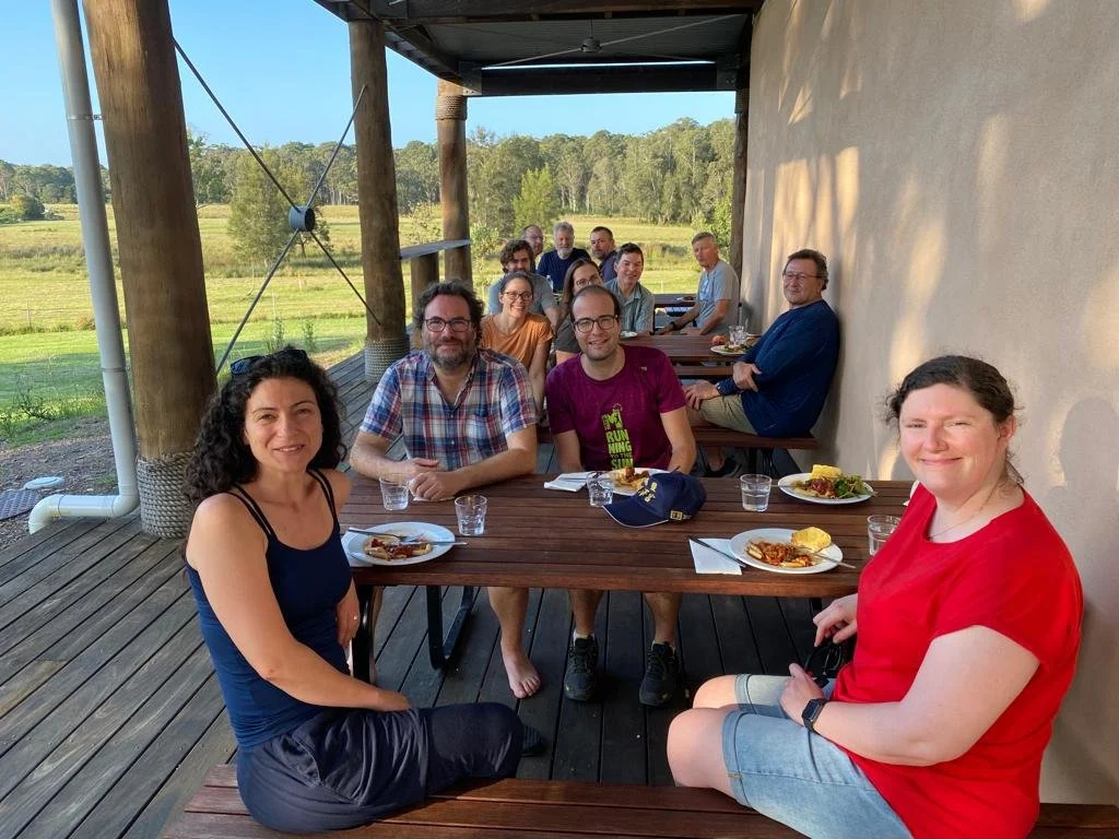
Figure 2: The research team. Picture was taken during a lunch break at a meeting of the MegaMove Steering and Operational Committees at the ANU, Kioloa Research Stating, in NSW, Australia, in 2023 – a pivotal meeting for the development of this article. From left to right and front row to back row: Ana Sequeira, Sarah Marley, Victor Eguiluz, Jorge Rodriguez, Michelle VanCompernole, Hannah Calich, Carlos Duarte, a guest (not co-author), Graeme Hays, Nuno Queiroz, David Sims, Mark Meekan, and Daniel Costa.