Mapping Resilient Landscapes to Climate Change in a Megadiverse Country

Leticia Garcia
Federal University of Mato Grosso do Sul
DOI: 10.25453/fpprize.32065857
Mapping Resilient Landscapes to Climate Change in a Megadiverse Country (Global Change Biology, 2025)
“When diverse landscapes are preserved, ecosystems and human communities, such as Indigenous people who depend on intact socio-ecological systems, are more likely to adapt.”
Climate instability and changes in land use have led to environmental degradation and a significant loss of species at rates far beyond the planet's historical limits. These impacts are not distributed uniformly, and the capacity of landscapes to buffer climate change depends on their physical characteristics and the spatial configuration connecting ecosystems. Based on this combination of factors, some landscapes have a greater capacity to adapt than others, functioning as refuges where biodiversity can persist in the face of current changes. Even with advances in climate modelling, there is limited spatial guidance to identify areas that can sustain biodiversity under projected climate conditions. On top of this, decision-makers have scarce resources to apply rapid and strategic actions to define areas to be restored, conserved, or maintained for sustainable use. Identifying resilient landscapes, therefore, provides a strategic basis for conservation planning and climate adaptation. We present a practical and effective way to define landscape resilience in the country considered the most biodiverse in the world, Brazil, encompassing multiple biomes of global ecological importance.
Because of the interrelationships between species and ecosystems, decisions made in this country, which is home to 20% of global biodiversity, have both direct and indirect effects on climate regulation, carbon stocks, the water cycle, soil stability, pest control, and global conservation. By mapping resilience in this central country for biodiversity, we show how managers may act to increase the chances of species accessing environments where they can survive in a world transformed by anthropogenic effects.
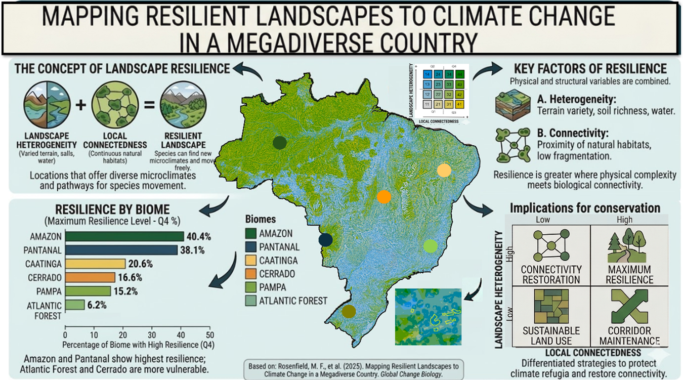
Figure 1: Infographic Mapping Resilient Landscapes to Climate Change in a Megadiverse Country.
What we found works on the ground and can scale up: a high‐resolution map showing where nature might persist despite climate shifts in one biologically rich tropical nation. It groups regions using two core traits: landscape heterogeneity and local connectedness. Landscape heterogeneity was used as a proxy for microclimatic variability, considering terrain variation. Areas with greater physical diversity tend to contain many microclimates. These environments allow organisms to survive nearby climatic shifts. Environments which cushion organisms against climate impacts matter when looking decades ahead. The other core trait, local connectedness, shows the degree to which landscapes facilitate or impede species’ movement and how well animals move across areas. By combining heterogeneity and connectedness, we classified the land into four types, each requiring a specific management approach with greater or lower capacity to sustain biodiversity under climate change. Our framework provides spatially explicit information to support conservation planning and restoration strategies. The approach is scalable and can be applied to other regions using widely available datasets.
The first type (the quadrant Q4) includes highly connected and heterogeneous landscapes that indicate extremely resilient systems. These regions can be considered natural climate refugia and are most likely to maintain ecological processes and biodiversity over time, being priority areas for conservation. Systems with low connectivity and high heterogeneity are connectivity-limited systems (Q2). Despite strong microclimatic potential, habitat loss has caused fragmentation. These regions are ideal for corridor creation through ecosystem restoration. Their resilience can be strengthened through strategic reconnection of fragmented patches. Landscapes with high connectivity but low heterogeneity serve as corridors for movement (Q3). They are crucial for preserving ecological flows and promoting adaptation through dispersal, even if they provide fewer microclimatic refuges. Protecting them ensures landscape permeability. The last type, low-resilience areas (Q1), can be used for sustainable land-use practices that provide ecosystem services with minimal biodiversity impact while preventing further degradation and sustaining livelihoods.
Implementation can occur in several ways. Governments may integrate resilience layers into policies concerning climate adaptation, protected area creation, and spatial planning, providing environmental agencies with scientific bases for zoning and licensing. These maps can also guide industry, particularly forestry, infrastructure, and agriculture, to prioritize restoration investments while making low-impact decisions. Focusing on Atlantic Forest and Cerrado connectivity-limited zones, where strategic restoration can generate the greatest resilience gains per area, is also important for civil society, as it can be cost-effective and supported by conservation finance initiatives.
Clear differences emerge between Brazilian biomes. The Amazon and Pantanal contain large areas with high resilience, demonstrating their global importance for climate adaptation and ecological stability. Conversely, the Atlantic Forest and Cerrado are fragmented and consequently have reduced resilience, requiring urgent connectivity policies and restoration priorities.
Because our methodology relies on globally accessible datasets and is fully scalable and replicable, any nation or region can apply the same principles to create its own resilience map. It is an effective tool for coordinating public and private investments with climate-resilient biodiversity strategies. Our research resulted in the development of a spatially explicit resilience database accessible to the public (available on Zenodo). By making the data publicly available, we democratize access to scientific analysis and facilitate better informed decision-making at all levels of governance.
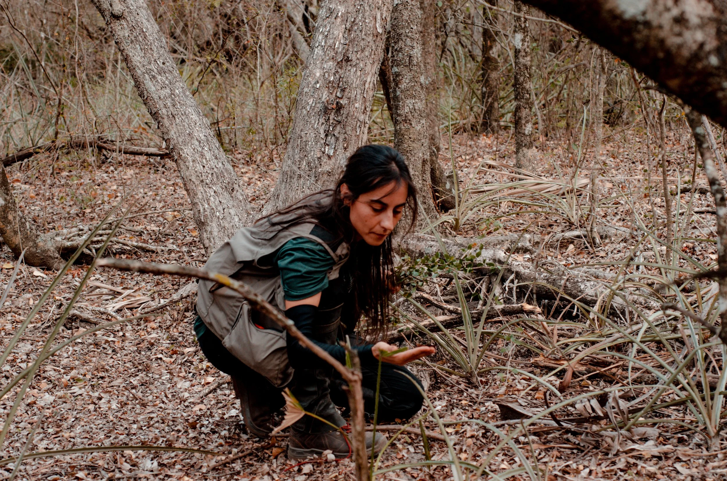
Figure 2: Photo of Letícia Garcia in the Kadiwéu indigenous land collecting palosanto seeds. Picture by Alice Rodrigues.
At scale, the framework facilitates applications that can direct funding for conservation and restoration toward effective results. First, it reinforces the scientific basis for improving protected area networks. It offers evidence for future-proofing conservation investments and protecting Indigenous and traditional territories that overlap with resilient zones by identifying high-resilience landscapes not currently under official protection. Second, it makes restoration commitments more effective. Brazil's restoration commitments under the UN Decade on Ecosystem Restoration (12 million hectares) can benefit from concentrating initiatives on connectivity-limited landscapes, where strategic corridors significantly increase resilience compared to random planting. Finally, local communities that directly depend on ecosystem stability can use these maps to identify biodiverse refuges to protect within their territories.
The science of planetary boundaries, specifically Biosphere Integrity and Land-System Change, is directly advanced by our research. By converting planetary thresholds into spatially explicit action zones, it offers an operational tool for identifying landscapes that are adaptable and resistant to change. We translate planetary risk assessments into planning maps by identifying landscapes with high buffering capacity and adaptive potential. Resilient landscapes possess structural conditions required to reorganize and sustain ecological function under stress. Ecosystems that regulate climate, preserve biodiversity, and support human well-being are essential to a safe operating environment for humanity. Our research provides a guide for restoring that stability. It shows where restoration can rebuild adaptive capacity, where conservation ensures long-term function, and where sustainable land use balances ecological limits and development.
We demonstrate the interdependence of planetary boundaries by bridging biodiversity science and climate adaptation. When diverse landscapes are preserved, ecosystems and human communities, such as Indigenous people who depend on intact socio-ecological systems, are more likely to adapt. Returning Earth's systems to a safe operating space requires proactive spatial planning that anticipates change rather than reacting to collapse. Our resilience framework provides this anticipatory lens. It illustrates how sustainable use balances development and ecological constraints, conservation ensures stability, and restoration rebuilds adaptive capacity. Our research turns resilience into a tool for planetary stewardship, ready for policy and offers a workable way to return Earth's systems to a more secure operating environment.